Ovaj oglas je prodan.
Pronjuškaj slične oglase.

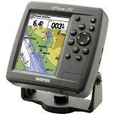


Garmin GPS ploter 182C
- Cijena
- 150 €
Šifra oglasa: 12672676
Osnovne informacije
- Lokacija
- Grad Zagreb
Opis oglasa
Povoljno prodajem Garmin GPSMAP 182C ploter s ekranom u boji. Potpuno je ispravan, sa stalkom za ugradnju u brod, poklopcem te jednom karticom s mapom (nije Jadranska obala).
Slijedi opis:
The GPSMAP 182C (with External Antenna) features crisp, high-resolution displays and high-speed processors, which allow for an extremely fast redraw rate. This chartplotters have a built-in WAAS receiver, which means they can pinpoint your location and other map features within three meters, on average.
The GPSMAP 182C has a built-in worldwide basemap which provides coastline detail, U.S. tide data, and inland cartography. The detail gets even better when you plug in an optional data card with GARMIN's exclusive BlueChart marine cartography or detailed maps from our MapSource product line*. Like all GARMIN marine products, these units are tough enough to stand up to saltwater, sunlight, and other elements.
The GPSMAP 182C offers daylight-viewable color as an option to the monochrome display of the GPSMAP 182.
* requires a Garmin Memory Data Card to download the MapSource Software to the GPS unit.
Features and Tips
Here is a list of GPSMAP 182CI features, along with a few user tips.
• Includes an Internal Antenna
• WAAS Enabled
• Dimensions: 6.18" H x 6.30"W x 2.6"D
• Display: 5.0" diagonal, sunlight readable, high resolution (234 x 320 pixels), 16-colour TFT
• Backlit display & keyboard
• 3000 user waypoints with name & graphic symbol; 50 reversible routes with 50 waypoints/route
• Compatible with Garmin BlueChart marine cartography and most MapSource products including MetroGuide.
• Audible alarms for anchor drag, arrival, off-course, proximity waypoint & clock
• Large number option for easy viewing
• Trip computer provides odometer, stopped time, moving average, overall average, total time, max speed
• 2500 point automatic track log; 15 saved tracks let you retrace your path in both directions, 500 points/saved track
• Course and speed filtering
• Built-in celestial tables for sun and moon calculations
- Oglas objavljen
- 06.09.2014. u 19:13
- Do isteka još
- oglas istekao
- Oglas prikazan
- 2579 puta